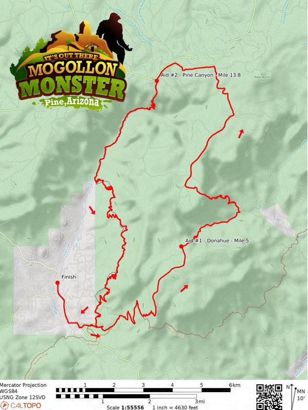
Mogollon Monster 42K Course Map & Aid StationS
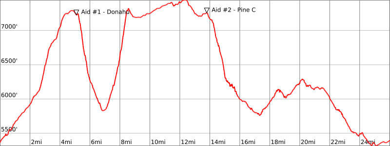
Mogollon Monster 42 Km Elevation Profile - Approx. 4,560 Feet of Gain/Descent
#1 Start to Donahue AS (Mile 5) – 5 Mile Segment
This sections starts out heading east from the Pine Trailhead along the Arizona Trail which is also the Highline Trail. You’ll follow this for approximately 2.5 miles to the turnoff for the Donohue Trail which will be to your left. This trail turns very rocky and climbs a series of switchbacks directly up the Mogollon Rim. The single track trail will eventually join a dirt road which you will lead you to the Donahue AS.
#2 Donahue Aid to Pine Canyon Aid (Mile 13.8) – 8.7 Mile Segment
From the aid, you'll quickly begin your steep descent off the Rim, following a series of switchbacks through tall Ponderosa pines and eventually a couple of small streams with ferns aplenty. You'll come to the end of the West Webber Trail and turn left on Turkey Springs Trail where you'll climb slowly at first, but then be treated to more of those short switchbacks surrounded by manzanita, cat claw, loose rocks and dirt as you ascend to the top of the Mogollon Rim for a second and final time.
Once you hit the road again and turn right, the road is in decent shape, tucked in the Coconino National Forest and doesn't have a ton of traffic so you can make up some time here as you head around Pine Canyon and eventually to the edge of the Rim. You'll now be on the same course as our 100 milers who are more than 85 miles into their journey so cheer everyone on and keep the stoke high.
#3 Pine Canyon Aid to Pine Trailhead (Mile 24.4) – 10.9 Mile Segment
Shortly after leaving the aid station, you'll be treated to an exceptional view south into Pine Canyon. Soak. it. up. From here, you'll descend almost 1,800 feet in 2 miles on switchbacks and back into the forest. There is a small stream on your left that may just be worth the effort of leaving the trail for a dip in at this time. Continue on this gorgeous trail, winding up, down, and around the canyon as you make your way closer and closer to the Pine Trailhead. Grab some water for the victory lap and keep going.
#4 Pine Trailhead (Water Only) to Finish at the Town Ramada (Mile 26) - 1.6 Mile Segment
This trailhead is less than 2 miles to the finish line. There’s no point in spending much time here unless you're in dire need of water. It’s a parking lot. It’s 2 miles from the finish.
Leaving Pine Trailhead, you’ll run down the paved road for the trailhead to just before the 87 highway. To cross the road you’ll drop down 15 feet to the right to a culvert access point and go UNDER the road in the tunnel. This is the safest way to get across what can be a busy road. The tunnel is free of debris and about 30ft long. On the opposite side you will be directed 100 meters to the right to Bradshaw Road. Go left down the hill to Old County Road and go right. This is all paved now and the road goes through a residential street until it meets up again with the 87 right where the Old County Inn & our Friday packet pickup were. Head left along the wide shoulder into the town of Pine. You have about ½ a mile left and it’s all through the town itself. Follow the wide shoulder inside the white line past the Pinewood Tavern, Ponderosa Market, old buildings and the finish line will be at the Community Center just after JP's Place and by the ice cream shop on Randall.
You’ll see the finish line.
I recommend a full sprint to the finish.