Trail History
Much of Arizona is steeped with the history of the Old West pioneer days and old mining history of the 1800's and early 1900's. The Mogollon Rim and the surrounding area that encompasses what is the Mogollon Monster course is no different and has a long history in ranching, Indian wars and gun battles. Ranchers on the land below the Rim in the Tonto Basin used to graze their cattle in the areas around Payson during the winters and come spring they would drive their cattle north onto the Rim to the lush, green meadows of the Cabin Loop region and beyond. There water was plentiful with springs, rivers, streams and ponds scattered about the forest while the Payson area below the Rim crept into the upper 90's and 100's and watering holes went dry, grass went scarce.
With Arizona ranching usually came a history of Indian wars as ranchers encroached on what was Indian land (or vice versa depending on who's telling the story.) The Apache's used to war with General George Crook all along the Rim itself in the 1870's as General Crook commanded the U.S. Army against the Yavapai & Tonto Apaches in protection of the white settlers and their land. The General Crook Trail (#300 and part of the MOG100 course) follows the edge of the Rim from the eastern town of Show Low, Arizona all the way west to Prescott, Arizona. What started as a meager wagon trail to get soldiers supplies to Camp Verde and Camp Whipple in the West during the wars slowly progressed into a more suitable road in the early 20th century and then to what it is today, primarily a dirt road with incredible views used for access to the Rim's amazing camping and hiking areas.
With Arizona ranching usually came a history of Indian wars as ranchers encroached on what was Indian land (or vice versa depending on who's telling the story.) The Apache's used to war with General George Crook all along the Rim itself in the 1870's as General Crook commanded the U.S. Army against the Yavapai & Tonto Apaches in protection of the white settlers and their land. The General Crook Trail (#300 and part of the MOG100 course) follows the edge of the Rim from the eastern town of Show Low, Arizona all the way west to Prescott, Arizona. What started as a meager wagon trail to get soldiers supplies to Camp Verde and Camp Whipple in the West during the wars slowly progressed into a more suitable road in the early 20th century and then to what it is today, primarily a dirt road with incredible views used for access to the Rim's amazing camping and hiking areas.
General Crook Trail - #300 - 128 miles
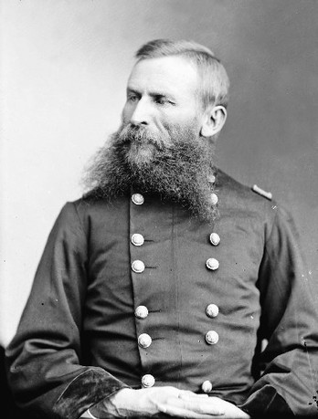
General George Crook - Indian Fighter, American Legend, Great Beard Grower
General George Crook was one of America's great military leaders before and after the Civil War. He fought Indians in the Pacific Northwest before the war, led troops during the Civil War. Then President Grant appointed General Crook to what was then the Arizona Territory in 1871 to fight off the Apaches and drive them onto to the reservation. Later he would head south in Arizona and spend four years battling Geromino and later fighting for Indian rights.
General Crook and his army built the General Crook Trail in the 1870's as a supply route to Prescott (Fort Whipple at the time) and a patrol for his Army scouts looking for Apache raid parties. They blazed the trail with two square chunks taken out of the Pines and then charred, these are still present today in some of the old growth along the course.
The General Crook trail started as one of the first major roads in Arizona and for years it was just a wagon trail but progressed gradually over the years and eventually was replaced with Forest Road #300 that runs along and crosses the General Crook trail several times. General Springs Cabin is named for General Crook as they used that location for overnight breaks on their way across the Rim. The Cabin was built in by the FS years later but the location was used by the troops for a rest area due to spring there and open meadow for camping.
For the MOG100 you will run the actual General Crook Trail for several miles on again and off again but the adjacent FS #300 plays a major role in the race course being that it connects all the trails from the Cabin Loop to the trails that lead back down the Rim to the Highline Trail.
The Highline Trail - #31 - 51 Miles
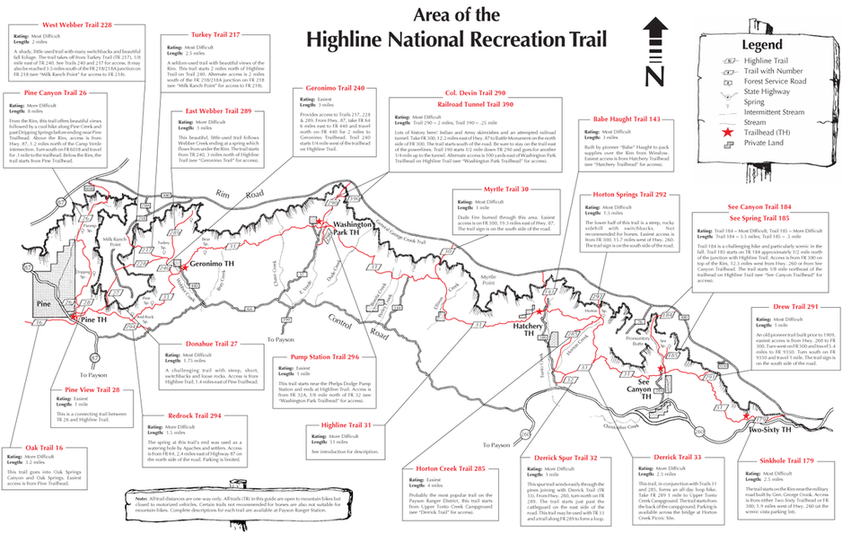
The "Backbone" of the Mogollon Monster 100 - The Historic Highline National Recreation Trail
The Highline Trail (#31) is a 51 mile east to west National Historic Trail that begins the Mogollon Monster 100 as it works it's way east and then west as you head back to the finish. This section of the trail is very difficult at times while offering some incredible single track running. This trail stays between 5,500 ft and 6,800 feet and will be the lowest points of the race as this trail provides the access to the climbs north onto the top of the Rim. This trail was used by pioneers and settlers as one of the only access ways from cabin to cabin and still today remains true to that providing access to the top of the Rim and surrounding areas.
The Cabin Loop
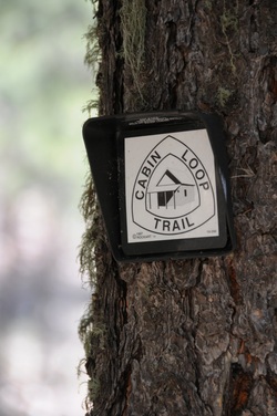
Trail Markers for the Cabin Loop.
The Cabin Loop on the top of the Rim is a series of trails used in the late 1800's by ranchers to push their cattle into higher grazing areas in the summer, full with water and out of the heat of the lower elevations. These series of trails (Fred Haught, Houston Brothers, U-Bar & Barbershop Trails) make up the "Cabin Loop" and offer some absolutely stunning single track running through ferns, aspens, oak, maple and pines. This area has minimal elevation gain with no major climbs as it stays between 7,200ft and 7,900 ft but provides some very fun, fast sections with it's meandering beauty in the forest and through open meadows. For those that know of this trail system it can be a runner's haven for Phoenix runners in the summers. When it's 110 degrees in July in Phoenix a quick drive to these trails can net you some 70 degree trail running.
As told by the National Forest Service:
The Cabin Loop Trail is the link between the earliest fire guard cabin network in this area of the Mogollon Rim and has its roots in the beginning of the Forest Service era here. The trail was developed between the General Springs Cabin, Pinchot Cabin and Buck Springs Fire Guard Station. Administratively, the cabins were part of the Bly Ranger District, now the Blue Ridge Office of the Mogollon Rim Ranger District.
The Bly Ranger District had a winter administrative headquarters at the Old Bly Ranger Station located about 10 miles north of the present Blue Ridge Office. The summer headquarters for the Bly District was the Blue Ridge cabin near Rock Crossing Campground. These two cabins are no longer in existence.
The trail passes through some of the most spectacular country in Arizona and you will encounter a variety of landforms, vegetative communities, and a number of springs and perennial water sources. It is important to remember that trails such as the Cabin Loop Trail provide the only access to the country in the early days. This and other trails were used and maintained by early Forest Rangers, ranchers and settlers. Livestock was driven up the Rim from the Tonto Basin and grazed during the summer up on the Rim. Portions of the trails are still used by ranchers for moving livestock. Historic accounts tell us that the old timers who made and used the trails blazed them to a height of 6 or 7 feet so the trails could be followed even after a deep snow. Maintenance and repair of the old telephone line was a priority for the rangers each spring. Their accounts indicate that snow lasted late here and it wasn't uncommon for them to have a ride over 4 foot drifts during spring rounds.
The Forest Service is proud of our history and we hope that you will enjoy your "walk into the past".
The Fred Haught Trail - #141 - (Cabin Loop Trail) - 6 Miles
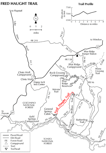
This historic trail is part of the Cabin Loop Trail system. It was named after a rancher who once used it to move cattle and supplies from ridge to ridge and valley to valley in the roadless wilderness above the Mogollon Rim. Today it provides hikers and horsebackers access to this scenic area of shallow canyons and forested ridges.
The Fred Haught trail was almost lost to neglect after a system of ridge top roads replaced it as the main route for commerce and travel in the 1950's. However, a renewed interest in the area by recreationists and history buffs inspired its recent reopening.
You'll find a hike along this trail leisurely and scenic, with a good chance to see wildlife and ample opportunity to imagine what it must have been like when horses and trails were the only way of traversing this picturesque countryside.
The monument of the Battle of Big Dry Wash shown below is just off of FR 300 at the beginning of the Fred Haught Trail, the site of the last major battle between the Apaches & U.S. Army.
Houston Brothers Trail - #171 - (Cabin Loop System) - 7 Miles
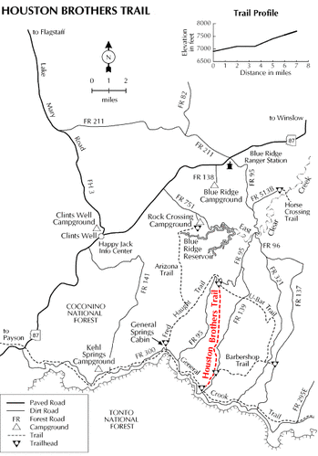
For much of its length the Houston Brothers Trail wanders along the bottom of Houston Draw, a picturesque little valley through which a spring-fed perennial stream flows. The scenery here is mostly pastoral with a few photogenic rock outcrops and aspen groves to remind you that you're in rim country.
This trail served a number of purposes during a heyday that stretched over most of the first half of this century. The Houston brothers were ranchers who used it for moving livestock from one part of the range to another. The Forest Service used the trail to move fire guards into isolated forest cabins where they were on twenty-four hour duty during times of high fire danger. Evidence of both of these pages out of the trail's history is visible at a number of locations, including a cabin site which Gifford Pinchot, father of the U. S. Forest Service singled out for its peaceful beauty. Today this trail is part of the Cabin Loop trail system, which provides an opportunity for Forest visitors to relive an aspect of Forest history while they enjoy the area's natural beauty.
This trail served a number of purposes during a heyday that stretched over most of the first half of this century. The Houston brothers were ranchers who used it for moving livestock from one part of the range to another. The Forest Service used the trail to move fire guards into isolated forest cabins where they were on twenty-four hour duty during times of high fire danger. Evidence of both of these pages out of the trail's history is visible at a number of locations, including a cabin site which Gifford Pinchot, father of the U. S. Forest Service singled out for its peaceful beauty. Today this trail is part of the Cabin Loop trail system, which provides an opportunity for Forest visitors to relive an aspect of Forest history while they enjoy the area's natural beauty.
Barbershop Trail - #91 - (Cabin Loop SYSTEM) - 4.5 Miles
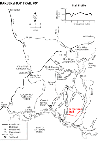
The rather unique name for this trail comes from a sheepherder who once lived in the area and was as good at clipping his fellow herders as he was at shearing woolies.
Barbershop Trail meanders through a pleasant region of open forests and shallow canyons and provides an excellent place to enjoy a woodland stroll or a weekend backpack. You'll find a wide variety of tree species here, including maple, aspen and oak, scattered among the more typical ponderosa pine and Douglas fir. The high proportion of deciduous trees makes this trail an especially colorful place in the fall, but there's plenty of wildlife to see at all seasons of the year. Watch for wild turkey, mule deer and elk. There are black bear in the area too, but they're much harder to see. Especially while you're so busy enjoying the scenery.
Barbershop Trail meanders through a pleasant region of open forests and shallow canyons and provides an excellent place to enjoy a woodland stroll or a weekend backpack. You'll find a wide variety of tree species here, including maple, aspen and oak, scattered among the more typical ponderosa pine and Douglas fir. The high proportion of deciduous trees makes this trail an especially colorful place in the fall, but there's plenty of wildlife to see at all seasons of the year. Watch for wild turkey, mule deer and elk. There are black bear in the area too, but they're much harder to see. Especially while you're so busy enjoying the scenery.
U-Bar Trail - #28 - (Cabin Loop SYstem) - 6.5 Miles
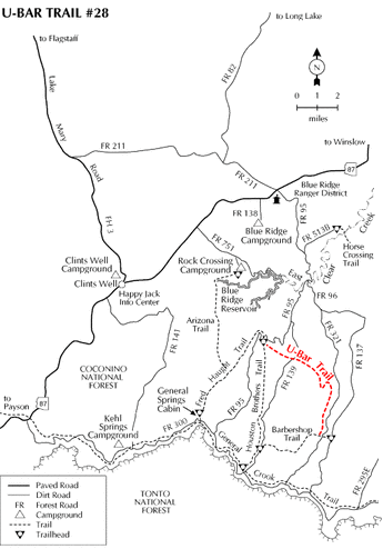
The U-Bar Trail leads into an area of forests, grasslands and canyons as rich in history as it is in scenery and wildlife. Before the current system of Forest Roads was installed, trails such as this one served as the equivalent of forest highways. They made it possible for Forest Service personnel, ranchers and hunters to move across the many canyons that carve this landscape into a series of rocky escarpments and grassy riparian areas. Portions of the old trail work, including piled rock berms are still visible along steeper sections of the route.
Today, the U Bar offers forest visitors the best means of access into this area of quiet canyons and ridges. The trails are excellent for hiking or horsebacking. The U Bar Trail can provide an enjoyable day hike, if you arrange a car shuttle with a hiking friend, or you may want to take a week off and hike the whole Cabin Loop.
Today, the U Bar offers forest visitors the best means of access into this area of quiet canyons and ridges. The trails are excellent for hiking or horsebacking. The U Bar Trail can provide an enjoyable day hike, if you arrange a car shuttle with a hiking friend, or you may want to take a week off and hike the whole Cabin Loop.
The Arizona Trail - AZT - Mexico to Utah
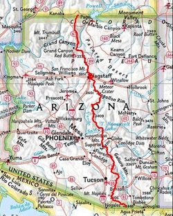
The Arizona Trail is a trail system that starts on the Arizona/Mexico border and continues north (or south depending on the person...) all the way to Utah. This 800+ mile route is now complete and will be a part of the Mogollon Monster 100 for several sections of the race- both the start and for a section of singletrack running on the Fred Haught Trail on the Cabin Loop. The AZT is incredibly challenging as a whole covering a vast variety of elevations, ecosystems and terrain from the Sonoran Desert to the forests of the Mogollon Rim to the Grand Canyon. www.aztrail.org