Mogollon Monster Training Run - August 10th
August 10th Training Run!We're headed out for another training run on the Mogollon Monster 100 course on August 10th. This time we'll again depart from Washington Park Trailhead east on the Highline Trail. We'll continue past where the Hell's Gate Aid Station will be come race day and to the Myrtle Trail ascent to the top of the Rim. Once we navigate the steep Myrtle Trail we'll cover some easy forest road miles to what will be the Buck Springs Aid Station during the race.
We'll jump into the forest from there and take the U-Bar all the way to Pinchot Cabin Aid Station location. From there it's 8 miles back on the Fred Haught Trail and then back down to Washington Park, descending off the Rim one final time.
This is a difficult section of the course covering about 35 miles in all. There is water at Dane Spring about 15 miles in but no other aid provided. Or water opportunities unless someone is going to be up there and can drop water. This covers miles 51-86 of the actual course in the same order runners will go on race day. However, most runners will run this in the dark so knowing the terrain in advance will come in very useful.
Let me know if you can make it. This is a really beautiful section of the course, challenging but really beautiful.
I'll be at the Wendy's parking lot off Shea & the 87 at 4:15am if anyone wants to follow me up or carpool. Just let me know for sure so I know to wait for you. This drive takes exactly 2 hours from my door on 13th Street and Northern in Phoenix to Washington Park Trailhead. It's 100 miles on the dot. It's about 90 minutes from Wendy's off the 87.
For those stat geeks out there...here's some previous data on the route we'll be covering: Here's the first five miles on the Highline from WP to Hell's Gate, a shared section with the Zane Grey 50M. http://app.strava.com/segments/4996589
Here's the rest of it...
http://app.strava.com/activities/8819018This is for Hell's Gate, up Myrtle and the rest of the way around.
FROM PAYSON
Take Hwy 87 North towards Pine, turn right at Fire Control Rd #199 (N Houston Mesa Rd.) for 8.5 miles. Following the signs to Washington Park, turn left on the Control Road to FS #32. Turn North on #32, through the community of Washington Park and follow signs to Washington Park Trailhead.
If you are planning on joining us please email me atazadventures@getoutgetlost.com so I have an idea of how many we have and who we may be waiting on at the start. There is also a Facebook Event for this weekend you can RSVP there as well. https://www.facebook.com/events/301633813313472/
We will be starting at 6 AM Saturday, August 10th!
Cabin Loop 50K Fat Ass - Sunday August 25th
This year we're heading out of the Phoenix heat for any possible excuse we can come up with. This will be a weekend of camping and running the Monster course! I'm heading up likelyFriday night and grabbing a spot by the river off the Highline Trail and will be running a 50K loop covering much of the trails we're going to be using for the race itself. We'll head up the Rim on the Arizona Trail, head east on the Rim Road to Houston Brothers Trail, then north into the forest on Houston Brothers a couple miles to the Barbershop Trail. Barbershop is only used very briefly at mile 65 but is a beautiful trail that connects the Houston Brothers over to U-Bar through a variety of canyon's and mountain meadow's. We'll head east on Barbershop to U-Bar and north to Pinchot Cabin. From Pinchot Cabin it's all the way south about 9 miles to the Rim Road and the final descent back down the Rim to Washington Park for the full 31 miles. Those wanting to do something slightly less can follow the Mogollon Monster section from 26-50 and simply continue on Houston Brothers to Pinchot and skip Barbershop/U-Bar for a 24 miler finishing at the same place at Washington Park. So we will mark the course on Saturdayand those that want a supported fun run in preparation of the Monster or just for a long run on some great trails are more than welcome. Feel free to join us on either day and if you want to camp as well, feel free!
Here is a link to the data on the shorter 24 miler which has about 3200 in climbing- http://app.strava.com/activities/66872362
Here's a link to the data for the full 50K: http://app.strava.com/activities/17984373/segments This one is a little off on the Barbershop trail but gives you an idea of the course.
Send me a RSVP at azadventures@getoutgetlost.com if you plan on joining us either day please! I'll set up a Facebook event as well soon for those that it's easier to go that route.
Want to Volunteer?!We have had a great response from the local running community in wanting to help out and get up on the Rim race weekend and run an aid station, help out and be there to support the race. We love hearing from you and it just makes it more exciting seeing the enthusiasm from everyone else. To keep our aid station allocations organized we'd like to have everyone interested in signing up to volunteer in any capacity to fill out the location and time slot they can commit to on the link below:
http://mog100.ivolunteer.com/mog100
You don't have to be an ultrarunner to volunteer so feel free to talk your friends and family into coming up for the weekend. The weather should be great, we should have some great aid station food and of course, the excitement and inevitable inspiration of seeing these runners work their way across this very challenging course. Many of the aid stations are used multiple times at very different times in the race so it will be interesting to see the same runners early on and then much later on in the race. Make those connections that first time through and cheer them on when they come back through!
Thank you all and we look forward to seeing you this fall!
Did you know that the Arizona Trail runs over 800 miles from Mexico through the Grand Canyon and into Utah? Along the way it cuts right through the Mogollon Monster 100 course. Entrants will converge on the AZT at the Geronimo Aid Station and follow it on the Highline Trail to the Washington Park Aid Station and then up to the top of the Rim. It continues north on the Fred Haught Trail before cutting west a few miles later on its way to Flagstaff. You'll see the metal Arizona Trail maps posted throughout the race where the AZT intersects. It's a challenging trail covering a great amount of diverse terrain. www.aztrail.org
Random TIdbits & FAQ's
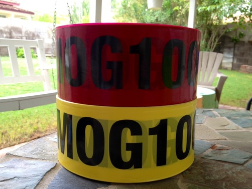 Yellow Good - Red Bad
 Course Marking - Course marking has come up a few times via email and Facebook and random other comments after last years race. Understandably for some and other comments that raise concern that some people won't find their way from point A to point B unless we pave the road and line the sidewalks with personal volunteers to make sure everyone makes it there safely. So to combat some of both of these challenges I've had these ribbons made for the race for our course marking. Last year we used standard orange surveying tape for the correct route and blue for the incorrect route. This was fine until there were trees with surveying tape or some was flung up in the wind in the trees, removed or in general missing.
So this is triple the width of standard surveyors tape and has our abbreviated name "MOG100" repeated for 1000 feet and I have a preposterous amount of each color tape. I did yellow for what is going to be the correct route you should be following. Red is going to now be the wrong way. So if you see red, you're off trail and you should turn around until you see another yellow tape. They will be marked adequately throughout single track and plastered for the intersections. I purposely bought a ton of this and we're going to use it. I also have some Department of Transportation quality reflective tape that is the same that the Tahoe Rim Trail 100 uses. John Vaupel, Founder of Trailrunningclub.com, recently finished the TRT100 a couple weeks ago and came back with the information that he loved the reflective tape they used as his light picked them up 50+ feet away they were so powerful. So I contacted the RD and asked what they used and it showed up at my house a couple days later. My neighbors probably think I'm getting robbed every night as I sit in my kitchen with my lights off flashing my headlamp over the test piece of the tape on the back wall of my yard. This stuff is awesome and far more reliable than glow sticks. We'll still use glow sticks but far fewer and just close to the aid stations.
I also picked up a number of sandwich board signs for the forest roads as confidence markers along the way and to make sure everyone makes the correct turns. The Turkey Springs/West Webber intersection will NOT be an issue this year.
We will be marking the course the weekend prior to the event if anyone is willing to help out.
Zane Grey Video - Have you seen this yet? This is hands down the best trail running video I have ever seen. Ever. Sure, Killian has some sweet video's but how realistic is it to see a runner flying up a 12,000 ft peak with no gear, no waters, and a helicopter videotaping him? It's not exactly an accurate depiction of what I experience when I fly. I mean, I carry gear.
This video however is exactly what Zane Grey is all about and why I have come to absolutely love the race in all it's glory and pain. They did an incredible job showing the area and why so many come back to this torturous area year after year. http://www.zanegrey50.com/photos_____video.html
Withdrawing from the Race - I'm not sure why you would do this unless you are pregnant and having a baby the week of the race. Outside of that I'm baffled but then I'm incredibly bias towards this race and I should probably understand that things pop up. When they do please refer to the part of the website that states that no refunds will be provided after March 1st. We are in our second year and purchasing all the start up equipment is not cheap as well as the supplies needed for the race now less than two months out. So I cannot refund your registration fee.
So you should just heal up, buck up, and show up. It's just more economical that way.
This Race is Hard - I feel like its necessary to repeat this mantra because of the emails that I get sometimes from prospective entrants makes me wonder if "trail running" to some people is the side of the country road. To be clear once again, this race is VERY HARD. It is very remote in many areas. You will encounter massive elk in breeding season. Entire sections of the Mogollon Rim have been shut down this summer from too many black bear sightings. They are all over the place up there, everyone and their mother gets to see one except the RD that goes up there every weekend....they are out there. Free range cattle will scare the living shit out of you on the Highline at 3am leaving Hell's Gate AS. Mountain lions are always out there somewhere and I pray that nobody ever encounters one during the race. There are javelina, rattlesnakes and we haven't even gotten to the part about an oversized hairy man beast legendary in the area. My point is, it's a wilderness area and its wild. The terrain is relentlessly tough like you've likely never seen before.
I know, I know, "sure, whatever." No, I'm serious. We had entrants from last year say it was a race for the "elite of the elite." I'll agree that's a silly assessment given two of our 9 finishers were 1st time hundreds (albeit locals familiar with the course) but it was said by many time 100 mile finishers. Accomplished in their own right and ultrarunners who thought they had run some "tough" courses. Not this tough.
This is Arizona and welcome to the Mogollon Rim country. This area is as "Old West" as it gets. The settlers of this area were not pansy's. They couldn't be and our entrants can't be if they plan on finishing. The terrain will beat you up, the heat will beat you up, the elevation will beat some of you up, and the never ending up's and down's and steep climbs will beat you all up.
Yet you have to press on and you have to keep moving.
So as much as I may talk myself into thinking, "this course isn't THAT hard" I'm constantly reminded every time someone joins me who isn't familiar with the trails and can't believe how hard they are.
The one resounding thought that always comes out of everyone that goes up there, "This is incredibly beautiful country." Because it really is. It's stunning. I find myself just staring off into the trees, over the 2,000 sheer cliff to the Highline Trail down below in the red rocks, off into the Mazatzal Mountains to the south. The place is as beautiful a land can be and we get to run straight through it all.
Tough it may be, but unbeatable it isn't. Come prepared for a Monster, because its prepared for you.
 RSS Feed